
The 7 main Camino de Santiago routes
24 min read
Table of Contents
The Camino de Santiago has many different routes. Each one offers a unique cultural and spiritual experience. The Camino de Santiago is not a single route like many people think referring to the most popular one – the Camino Frances. It’s a network of pilgrimage routes that start in different places across Europe and finish in Santiago de Compostela, Spain. In fact, you can start walking to Santiago from anywhere in Europe.

As of March 2024, we’ve completed 9 Camino de Santiago routes. 7 main routes: Camino Frances, Camino Portuguese (Coastal and Central Route twice), Camino del Norte, Camino Primitivo, Camino Ingles, Camino Finisterre-Muxia, and Via de la Plata. And two lesser-known Camino routes: Camino de San Salvador, and Camino de Gran Canaria. We’re planning to walk more routes in 2024.
We have created the Camino de Santiago resource page where all our Camino posts are divided into relevant groups. It makes it easier to navigate and find the information you’re looking for.
Camino de Santiago routes map


What is the most popular Camino de Santiago route?
The Camino Frances is by far the most popular Camino de Santiago route. Most people walking the Camino Frances don’t complete the entire route but only the last 100 km from Sarria to Santiago. The Portuguese Camino de Santiago is the second most popular route.
Below you can see the number of pilgrims on different Camino routes according to the information from the Pilgrim’s Receptions Office in Santiago de Compostela.
In 2023 in total 446 042 pilgrims arrived in Santiago de Compostela after completing one of the Camino routes.
| Camino route | In 2023 |
| Camino Francés | 49,7% – 219 787 pilgrims |
| Camino Portuguese (Central + Coastal routes) | 32% – 141 465 pilgrims Central route: 20% – 88 718 Coastal route: 12% – 52 747 |
| Camino Ingles | 5,4% – 24 094 pilgrims |
| Camino Primitivo | 4,7% – 20 714 pilgrims |
| Camino del Norte | 4,6% – 20 583 pilgrims |
| Via de la Plata | 1,8% – 7 964 pilgrims |
The Pilgrim’s Reception Office in Santiago doesn’t have exact numbers for the Camino Finisterre-Muxía. People usually walk this route after finishing one of the other (longer) Camino routes.
What is the best Camino route for beginners?
We often get this question. I’d say one of the most popular Camino routes e.g. Camino Frances or Camino Portuguese from Porto is the best route for beginners. Why? Simply because these routes have a very good infrastructure which means it’s easy to find accommodation, support, and help. The easiest option is to walk the last 100 km to Santiago de Compostela on one of the two routes from Sarria on the Camino Frances or from Tui on the Camino Portuguese. If you want to complete a longer route then the Portuguese Camino from Porto (the Coastal or the Central route) is probably one of the best options.
What is the hardest Camino de Santiago route?
Out of the seven main Camino de Santiago routes I’d say the Via de La Plata is the toughest route. First of all, because it’s the longest route. Second, because distances between towns are very long sometimes you walk 20-25km though nothing which means you have to carry a lot of water and some food with you. Third, it gets very hot in summer and quite cold in winter in that part of Spain you have to find the perfect time between the two seasons.
In my opinion, the Camino del Norte is the second toughest Camino de Santiago route because of its long distance and many ascents and descents on the route.
The part of the Portuguese Camino from Lisbon to Porto is quite challenging as well because of the long distance between towns and limited accommodation options.
The main Camino de Santiago routes are arranged by distance:
- Via de la Plata – 1000 km/621 mi
- Camino del Norte – 825 km/512 mi
- Camino Francés – 790 km/490 mi
- Camino Portugués from Lisbon – 616 km/382 mi
- Camino Primitivo – 321 km/199 mi
- Camino Portugues from Porto* – 260 km/161 mi (Central Route), 280 km/173 mi (Coastal Route)
- Camino Inglés – 120 km/74 mi
- Camino Finisterre-Muxía – 115 km/71 mi
*I decided to add the route from Lisbon as a separate Camino because the majority of pilgrims start walking the Portuguese Way from Porto.
What is the most beautiful Camino de Santiago route?
It’s difficult to say which Camino de Santiago route is the most beautiful. Each route has something different to offer. Some people enjoy the forest, some mountains, and some sea.
After walking 9 different routes I’d say the Camino del Norte (a coastal route through Northern Spain) is our favorite Camino. It’s the most beautiful coastal Camino de Santiago. We enjoyed walking next to the sea. There are quite a few interesting cities and towns on the route as well. It’s a great combination of spectacular nature and impressive architecture.
If you prefer mountainous scenery the Camino Primitivo and the Camino del Salvador are the two most scenic routes through the mountains. These two routes offer more of a hiking experience with fewer cities and towns.
Another route that is one of our favorites for the scenery is the Camino de Gran Canaria. It’s a 3-4 day Camino on the Canary Islands that connects two beaches and takes hikers through the lush-green tropical forest and mountains. It’s a great route to take in winter.
As for the most popular route the Camino Frances it has some incredible days and beautiful cities but I’m not a big fan of walking through the plains which make a big part of the route.
Which Camino route is the best for you?
Which Camino route is the best? is one of the most frequently asked Camino questions we get. It depends on several aspects.
- Decide how far you want to walk – short, middle, or long-distance route. You always can start a route not from its official beginning but from the point on the route that suits you the best.
- Choose the best route for the month you want to walk – not too hot, not too much rain.
- Determine what you want to see; coast, beach, forest, mountains, historical cities.
- Decide if you want to walk a busy and very social Camino route or rather have a solitary walk.
The seven main Camino de Santiago routes
There are seven main routes of St.James; Camino Frances (the French Way), Camino Portugués (the Portuguese Way), Camino del Norte (the Northern Way), Camino Primitivo (the Original Way), Via de la Plata (the Silver Way), Camino Inglés (the English Way) and Camino Finisterre-Muxía. These Camino routes are well-marked, have enough infrastructure for pilgrims, and don’t require very thorough planning – you just choose one and follow the yellow arrows to Santiago.
| Long-distance routes | Middle-distance routes | Short-distance routes |
| Camino Portuguese from Lisbon – 616 km | Camino Portuguese from Porto – 260 km | Camino Inglés – 110 km |
| Camino Francés – 790 km | Camino Primitivo – 321 km | Camino Finisterre – 118 km |
| Camino del Norte – 825 km | ||
| Vía de la Plata – 1000 km |
As I already mentioned we’ve walked all seven main routes. Below we give our personal opinion on the seven Camino routes. The routes are arranged according to their popularity.
Disclosure: Stingy Nomads take part in the Amazon Services LLC Associates Program. When you buy something recommended in this post, we may get an affiliate commission — but it never affects your price or what we pick.
Camino Francés (the French Way)
- Distance – 790 km/490 mi
- Days required – 28-35
- Starting point – Saint-Jean-Pied-de-Port (France)
- Regions – Navarra, La Rioja, Castilla y León, Galicia.
- It can be combined with – Camino Primitivo (from León), Camino Finisterre-Muxia (from Santiago de Compostela)
Best guidebook for the Camino route – A Pilgrim’s Guide to the Camino de Santiago (Camino Francés): St. Jean Pied de Port • Santiago de Compostela, John Brierley, 2022
Main cities and towns on the route
There are many historical cities and towns on this route;
- Pamplona
- Logroño
- Burgos
- León
- Astorga
- Ponferrada
- Melide
- Santiago de Compostela.
Best walking months
This route can be walked all year round, many albergues stay open all year. A good thing about walking the Camino Francés offseason is that there will be not many people. As for the weather, May-June and September-October are probably the best walking months. It gets very hot and very busy in July and August. In the last years, September (especially the beginning of the month) has become a very popular month for walking the French Way.
We prefer walking any Camino before the peak season, in spring. Many albergues do the complete cleaning and sanitization before the beginning of the new season which means your chances of getting bed bugs are much smaller than at the end of the season.


The Camino Francés is the busiest Camino route. For many people the Camino de Santiago = Camino Francés. The popularity of this route was the main reason we didn’t want to walk it but in the end, I decided to do the French Way to be able to compare it with other Camino routes. I walked it in September and there were many people. For 90% of all pilgrims I met, it was their first Camino de Santiago. Many people do the French Camino alone it’ll be easy to find a company.
The French Camino out of all routes has the best infrastructure and the most albergues. Some of the albergues are open all year round which means this route can be completed off-season, in winter months.
It’s possible to combine the French Camino with the Camino Primitivo. There is a split in León; one route continues west towards Santiago, and the second route goes north to Oviedo (the beginning of the Camino Primitivo) following the Camino de San Salvador.
What we liked about the route
- It’s cheap to walk the French Camino. There are many public albergues and albergues for donation along the route you can find one for every night.
- This route goes through some amazing Spanish cities such as Pamplona, Logroño, Burgos, León, and Astorga.
- It’s a very social Camino every day you get to know new people by the end of the walk you know pretty much everybody on the route.
What we didn’t like
It’s a very busy route in the peak season people start chasing for beds to make sure they get one when they arrive. It’s not a big problem if you end your day in a big city there are plenty of hostels and hotels but if you’re walking to a small place I’d recommend booking a bed in advance.
The scenery, the part of walking through the famous Meseta (plains and fields with nothing) was not my favorite. It’s just not my kind of scenery, I prefer mountains, forests, or the coast. I know some people enjoy this part.
Difficulty level
Knowing that for many people it’ll be their first Camino de Santiago I’d say 4 out of 5. It’s a long route, and the distance of 790km is already a big challenge. If you walk in summer it gets very hot in Meseta and there is no shade to hide you have to start your day early at 5.30-6.00 am. There are some days with steep and long ascents and descents which can be a problem for some pilgrims.
Scenery overview
The middle section of the Camino from Burgos to Astorga is through the Meseta with wheat fields dominating the landscape. For days you walk through plains with occasional trees and villages. There are very few rivers, lakes, or big water bodies on this route. My favorite part was the beginning of the Camino from St.Jean Pied de Port to Pamplona (over the Pyrenees) with beautiful mountain views and lush green forest. I liked the part of the route from Astorga to O Cebreiro for the same reason; mountains, forest, small villages.


Camino Portugués (the Portuguese Way)
- Distance – from Lisbon – 616 km/382 mi, from Porto (Coastal Route) – 280 km/173 mi, from Porto (Central Route) – 260 km/161 mi.
- Days required – from Lisbon – 25-27, Coastal Route from Porto – 12-14, Central Route from Porto – 11-13.
- Starting point – Lisbon or Porto.
- Regions – Portugal; Estremadura, Ribatejo, Beira, Douro Litoral and Minho. Spain; Galicia.
- It can be combined with – Camino Finisterre-Muxia (from Santiago).
The best guidebook for the route – A Pilgrim’s Guide to the Camino Portugués Lisbon – Porto – Santiago: including Camino Central, Variente Espiritual, Camino da Costa, & Senda Litoral, John Brierley, 2022
Main cities and towns on the route
- Lisbon,
- Santarém
- Fátima (the alternative route through Fatima)
- Coimbra
- Porto
- Barcelos (Central Route)
- Ponte de Lima (Central Route)
- Viana do Castelo (Coastal Route)
- Caminha (Coastal Route)
- Vigo (Coastal Route)
- Tui (Central Route)
- Pontevedra
- Santiago de Compostela
Best walking months
The best time for walking this Camino route is between the end of April and July and September-October. In July and September, it can be quite hot on the Lisbon-Porto stretch. August is fine if you start walking from Porto. If you walk from Lisbon it’ll be very hot, the route goes through the fields and plains with no shade. We walked the Portuguese Camino from Lisbon in May and had very good weather; warm, even hot some days, with no rain, the scenery was beautiful with many wildflowers and trees in blossom.


The Camino Portuguese starts from the Sé Cathedral in Lisbon but as I already mentioned most people walk from Porto. We walked from Lisbon and that part of the Camino has less infrastructure; the route is marked well but there are not many albergues (especially public) on the stretch between Lisbon and Porto which means you end up paying more for accommodation. It’s possible to combine the Portuguese Camino from Lisbon with the Camino de Fátima.
From Porto, there are two routes; the Central (original) route and the Coastal (new) route. Both routes merge in Redondela, both have albergues and route markers. The Coastal Route is 280km, and the Central Route – 260 km. Most pilgrims walk the Central Route, and only about 20% of people who walk the Portuguese Camino follow the Coastal Way.
There is another route option on the Portuguese Camino – the Spiritual Variant (Variante Espiritual). From Pontevedra, it goes towards the coast and joins again with the main Portuguese route in Padrón. This way is 1 day longer than the standard route, it involves two walking days and one day on a boat.
What we liked about the route
- We walked in spring the fields were covered in flowers
- Beautiful sea scenery on the Coastal Route
- Interesting historical towns on the Central Route
- Not too many people (very few from Lisbon to Porto)
What we didn’t like
- Our main dislike is for the Lisbon-Porto part; not enough albergues on the route, and long distances between them.
Difficulty level
4 out of 5 for the Camino route from Lisbon to Porto due to long stretches through nothing and long distances between albergues. 3 out of 5 for the part from Porto to Santiago, easy walk with no hills or mountains to conquer, many albergues and facilities on the way, relatively short distance – 260-280km. The main challenge for us here was the walking surface, walking on asphalt and cobblestones, both are hard on your feet if it wasn’t for that we’d rate it as an easy 2 out of 5.
Scenery overview
Countryside with many crop fields and vineyards and a couple of historical cities on the part between Lisbon and Porto, the Central Route from Porto has a similar scenery. The Coastal Route from Porto is all about the sea; beaches, coast, fishermen’s villages, etc.


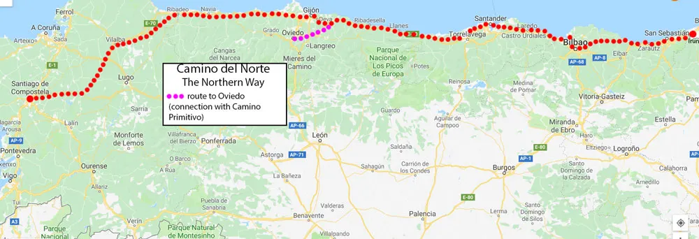
Camino del Norte (the Northern Way)
- Distance – 825 km/512 mi
- Days required – 30-35
- Starting point – Irún
- Regions; the Basque Country, Cantabria, Asturias, Galicia
- It can be combined with – Camino Primitivo (from Gijon) and Camino Finisterre-Muxia from Santiago.
The best guidebook for the route – Camino del Norte: Irún to Santiago along Spain’s Northern Coast (Village to Village Map Guide), 2019
Main cities and towns on the route
- San Sebastián
- Guernica
- Bilbao
- Portugalete
- Castro Urdiales
- Santander
- Santillana del Mar
- Comillas
- Llanes
- Gijón
- Avilés
- Ribadeo (Coastal Route)
- Santiago de Compostela
Best walking months
June to September is a good time for this route, July and August are the busiest months, with many tourists in beach towns, and most pilgrims on the Camino but a good thing about walking during these two months is that all public albergues are open for that period. We walked this route in October and most of the time had very good weather; warm and dry.

The Camino del Norte is one of the oldest Camino routes, it was a popular route in the Middle centuries during the Moorish invasion as other routes, located more to the south, were not safe due to the Moorish troops progressing to the north of Spain. Nowadays this route is gaining popularity as a good alternative to the overcrowded Camino Francés.
The Northern Way is one of the longest Camino de Santiago routes. It’s one of our favorites. We’re big fans of the ocean and liked the walk, especially the first half of it through the Basque Country and Cantabria. The route offers spectacular coastal scenery, and we found it is a great alternative to the French Way; the distance is about the same, 800km vs 825km, the route is less crowded, and it follows the coast (the French Way goes all the way inland), goes through historical cities and towns with many interesting sights.
Camino del Norte is considered to be tougher than Camino Frances because of multiple ascents and descents on the way but it doesn’t have any mountain passes like the French route. The route is well-marked all the way and has several alternative route splits.
It’s possible to combine Camino del Norte with Camino Primitivo, the route splits just before Gijón, and it’s two walking days to Oviedo where the Primitive Camino starts. The route to Oviedo is well-marked and has albergues for pilgrims like any other Camino. The Camino del Norte merges with the Camino Frances in Arzua, 40km before Santiago de Compostela.
What we like about the route
- Beautiful sea scenery
- Great food (especially in the Basque Country)
- Several interesting historical cities and towns
- Not too many pilgrims
What we didn’t like
- Many public albergues in the Basque Country are opened only in July and August, outside this period pilgrims have to pay more and stay in private albergues.
Difficulty level
4 out of 5; long route, many ascends and descends on the way, a couple of stages with long distances between towns, albergues, places to stop for food, etc.
Scenery overview
About 60% of the walk is along the coast; beautiful sea scenery, beaches, green hills, cozy towns, and a little bit of forest, mostly in Galicia. Walking this route we often regretted not having enough time to explore some parts of the Camino, we’d like to stay longer than just one night in several places on the way, many of them are now on our bucket list to visit.


Camino Primitivo (the Original Way)
- Distance – 321 km/200 mi
- Days required – 12-15
- Starting point – Oviedo
- Regions – Asturias, Galicia
- It can be combined with – Camino Finisterre-Muxia (from Santiago)
The best guidebook for the route – Camino Primitivo: Oviedo to Santiago on Spain’s Original Way, 2019
Main cities and towns on the route
There are very few cities and big towns on this Camino
- Oviedo
- Lugo
- Melide
- Santiago de Compostela
Best walking months
June – August are the warmest months with the least rainfall but because most of the route goes over the mountains the weather there is quite unpredictable, we walked this Camino in June and got a lot of rain.


The history of the Camino de Santiago dates back to the 9th century when the first pilgrims walked to Santiago de Compostela to commemorate the discovery of the tomb of the Apostle St.James. The Camino Primitivo or the Original Way is believed to be the first Camino ever walked. According to the historical manuscripts Spanish King Alfonso II walked from Oviedo to Santiago de Compostela in the 9th century.
It’s often named the toughest Camino because the route goes through the mountains in Asturias. It’s partly true the Original Way does have many ascends and descends (some are quite long and steep) but the total distance of the route is quite short, for us, the Northern Way was more challenging.
The Primitive Way is probably the closest to the wild hike Camino, most of the time you walk on the walking path through the forest or over the mountains, past small villages and towns (but not as many as on the other routes). There is not much walking on the road or the sidewalk but if you have any knee issues it might be difficult to complete this route due to many ups and downs.
Camino Primitivo can be walked as a part of Camino Francés or Camino del Norte both have connecting routes to Oviedo. This route merges with the Camino Frances in Melide, 52km before Santiago.
What we liked about the route
- “Wild Camino” with a lot of walking on the footpath, trails, through remote areas, very few cities, no industrial areas, and busy roads on the way.
- Public albergues can be found at the end of every walking stage, you can easily complete the whole route staying only in public albergues, which makes the walk cheaper.
- The Camino goes through off-the-beaten-track areas with few tourists besides the pilgrims.
- Locals are very friendly and hospitable they’re not sick of thousands of tourists passing by every day.
What we didn’t like
- We were very unlucky with the weather even though we walked the Camino in summer (June), we had a lot of rain and mud on the trails it was our only dislike. Otherwise, it’s a great Camino to walk with good facilities and stunning scenery.
Difficulty level
4 out of 5, many steep ascends and descends but the route is relatively short as well as the walking stages.
Scenery overview
Beautiful mountain and forest scenery, the trail goes through some remote areas of Asturias, with no cities or big towns on the way.


Camino Inglés (the English Way)
- Distance – 116 km/72 mi from Ferrol, 74 km/46 mi from A Coruña
- Days required – 4-6
- Starting point – Ferrol or A Coruña
- Regions – Galicia
- It can be combined with – Camino Finisterre-Muxia (from Santiago)
The best guidebook – A Pilgrim’s Guide to the Camino Inglés: The English Way also known as the Celtic Camino: Ferrol & Coruña — Santiago, John Brierley, 2021
Main cities and towns on the route
A Coruña or Ferrol (depending on where you start) and Santiago de Compostela.
Best walking months
June – September, the beginning of October, and the second half of May, though in our experience it can rain any time in Galicia.


The Camino Inglés is probably the best Camino for those who just want to get a taste of the walk without embracing a long journey. It’s easy to combine this route with a normal (non-walking) beach or sightseeing holiday and find out if the Camino is your cup of tea or not, after completing the English Way you can decide if you want to spend your next holiday walking. There are no big cities or towns on the way more of countryside scenery and forest – traditional Galician landscape.
We haven’t walked from A Coruña but some sources say the route from there is not marked very well. Note! If you start walking from A Coruña you won’t be able to get the Compostela for this Camino because the total distance is under 100 km. The Camino from Ferrol has proper marking and good infrastructure.
What we liked about the route
- A short Camino de Santiago route can be done as a part of a holiday or over a long weekend.
- The English Way is a perfect option for first-time pilgrims, it gives a good idea about walking the Camino. After completing it you can decide whether you like it or not before planning to walk one of the longer routes.
- It’s a quiet route with not too many people.
- There are no big cities or industrial areas on the way more of the countryside scenery and forest.
What we didn’t like
- My main dislike was the walking surface on this route, a lot of walking on sidewalks and tar roads.
Difficulty level
Though the Camino Inglés is a short route I’d give it 3 out of 5 due to multiple ascents and descents on the way.
Scenery overview
A typical Galician scenery, a mixture of pasture fields and lush green forest with a little bit of sea scenery and a couple of beaches in the beginning. Some parts e.g. on the last day to Santiago were truly beautiful.


Via de la Plata (the Silver Route)
- Distance – 1000 km/621 mi
- Days required – 40-50 days
- Starting point – Seville
- Regions – Andalucía, Extremadura, Castilla y León, Galicia
- It can be combined with – the Camino Frances (from Astorga)
The best guidebook – The Vía de la Plata and the Camino Sanabrés – A Guide to the Camino from Sevilla to Santiago [2022 Edition]
Main cities and towns on the route
Despite the length, there are not many big cities and towns on this route
- Seville
- Itálica
- Mérida
- Cáceres
- Salamanca
- Zamora
- Ourense
- Santiago de Compostela
Best walking months
April and May, when it’s warm but not too hot yet. In autumn it cools down only in October. Walking Via de la Plata between July and September is not a good idea, the temperature in Andalucía and Extremadura in August reaches 40C°, it’s very dry and hot.


The Via de la Plata or the Silver Way follows an old Roman road that headed to the mines in Northern Spain. Later the route was used for many other purposes e.g. moving stock from south to north in summer, trading, migratory, etc. It was used as a pilgrimage route to Santiago between the 10th and the 12th centuries, later very few pilgrims walked it. Nowadays the route has good facilities and enough infrastructure though it’s still walked by only 3% of pilgrims every year.
This route is not recommended to walk as the first Camino due to the distance, fewer facilities on the way, and long stages. For planning this walk it’s important to keep in mind the seasons. It’s very crucial to carry enough water and use sun protection (sunscreen and hat) on Via de la Plata. By now we’ve walked only 214 km on this route from Seville to Mérida.
The route splits after Zamora; one goes to Astorga where it merges with the French Camino another continues to Santiago through Ourense (this part is also known as Camino Sanabrés).
What we liked about the route
- Walking surface, compared to some other routes, on the Via de la Plata there is not much asphalt or road walking.
- Some impressive Roman ruins on the route, e.g. Italica, Mérida, etc.
- Though the towns on the route are far apart in every place we stopped we could find an ATM and a shop/supermarket.
- No walking through industrial or urban areas of big cities, most of the time very peaceful countryside and fields.
What we didn’t like
- Long stages with nothing in between, no towns or villages, and no even places to refill water, you walk an average of 20-25 km through the fields with nowhere to stop.
- Public albergues are a bit more expensive on the Silver Route compared to the other Camino de Santiago routes, with an average price of 10€ per person vs the usual 8€.
Difficulty level
I’d say 5 out of 5, a very long route combined with long stages and little infrastructure in between, plus weather conditions if you walk this Camino in summer it’s incredibly hot.
Scenery overview
A lot of walking through the fields, past vineyards, and olive tree plantations with some interesting Roman ruins on the way. In spring the area is covered in wildflowers.


Camino Finisterre-Muxía
- Distance – Santiago-Finisterre – 89 km/55 mi, Santiago-Muxía – 86 km/53 mi, Santiago-Muxía-Finisterre – 115 km/71 mi.
- Days required – 3-5
- Starting point – Santiago de Compostela.
- Finishing point – Finisterre or Muxía
- Regions – Galicia
- It can be walked as an extension after completing any other Camin route
The best guidebook – A Pilgrim’s Guide to the Camino Finisterre: Including Muxía Circuit: Santiago ― Finisterre ― Muxía ― Santiago, John Brierley, 2022
Main cities and towns on the Camino route
There are no cities between the beginning and the end of the Camino; Santiago de Compostela, Finisterre, and Muxía
Best walking months
June to September. We walked this Camino in November and got a lot of rain and stormy wind on the way to Finisterre.


The name Finisterre comes from the Latin “finis terrae” which means “end of the earth”, the origin of the pilgrimage to Cape Finisterre goes back to pre-Christian times when people believed it was the edge of the world.
The Camino Finisterre is usually walked as an extension after completing one of the other Camino routes but it can be walked as a separate Camino as well. It can be a good option for those who are not sure if they want/will be able to walk a longer route of the Camino de Santiago, some sort of Camino test drive. The Camino Finisterre-Muxía is the only Camino de Santiago route that starts in Santiago de Compostela.
There are two finishing points; Finisterre and Muxía, both are small sea towns at two capes. It’s possible to walk to both of them the Camino route connects two towns, it’s the most scenic part of the route by the way. After completing this Camino you can get the Finisterrana and Muxiana certificates. There are many albergues, restaurants, and cafes on the route, even in peak season you won’t have a problem finding a place to sleep.
What we liked about the route
- Beautiful sea scenery at Finisterre and Muxía
- Relaxed vibe maybe it feels that way because most people who walk this route have already finished one Camino route and are pretty chilled.
What we disliked
- Our main dislike was too much rain and strong wind we got on the route but I must say we walked it in November, not the best time of the year.
- Very few supermarkets and shops are on the way which makes it difficult to make food.
Difficulty level
2 out of 5 – short route, frequent places to stop for food, many albergues, well-marked, some ups and downs on the way, one quite steep and long ascent on the first day (if it wasn’t for that I’d give it 1 out of 5).
Scenery overview
Forest and fields most of the way, beautiful sea views on the stretch between Finisterre and Muxía, and at both capes.


Camino de Santiago planning resources
Questions or Comments?
Got any questions or comments? We would love to help! All questions and comments will be answered by us personally in Buy Me a Coffee. Click below and ask away.
Feel free to support our site by buying us a coffee!
LIKED THIS POST? PIN IT!


Disclosure: Stingy Nomads take part in the Amazon Services LLC Associates Program. We earn advertising fees by advertising and linking to Amazon.com. If you click on the link and purchase the item, we will receive an affiliate commission at no extra cost for you. Thank You!
Please follow and like us:


The pretty half of Stingy Nomads, responsible for all our land adventures (hiking, climbing, walking the Camino) and following them write-ups. Alya loves walking since she was a child, she prefers to walk 1000 km with a backpack rather than to do a 10 000 km road trip (actually any road trip). Alya is a big fan of Latin America, the Spanish language, and dancing. Every time we go away she desperately misses our dog Chile.


