
12 Best Hikes In Zermatt (Easy, Medium & Challenging + Map)
13 min read")
Table of Contents
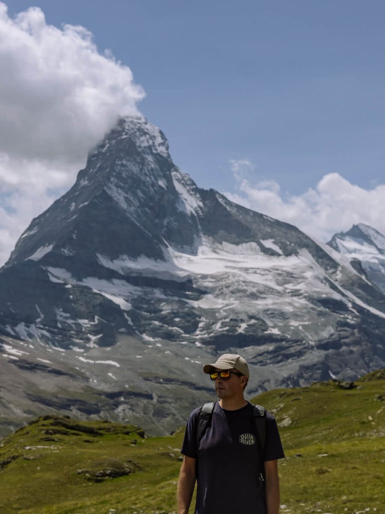
Zermatt is one of the best walking destinations in Switzerland with well-marked trails and iconic landmarks. Enjoy a range of exhilarating hikes from easy to strenuous, using the Matterhorn as your compass.
Dominating Zermatt is the Matterhorn. The iconic pyramidal mountain with sheer sides, rising above a sea of ice and rock.
But there are plenty of other noteworthy landmarks to explore hiking in Zermatt.
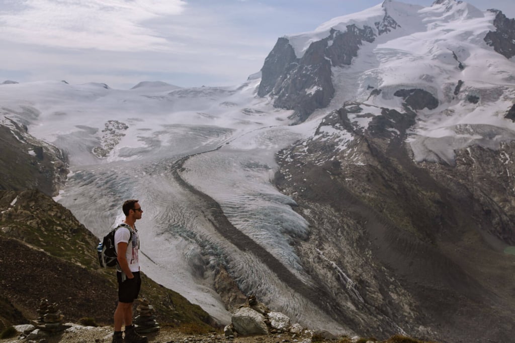
Across the valley, the Gorner Glacier is an enormous curve of ice. Circling Dufourspitze, the highest mountain in Switzerland, it’s a tremendous sight.
Less dramatic is the maze of trails exploring the Alpine lakes, meadows, and narrow gorges.
Beautiful Swiss villages and high mountain huts offer refuge and refreshment.
Our guide to the best hikes in Zermatt includes maps, detailed instructions, and some tips on getting the most out of your hiking holiday.
COMMENTS // We do our best to keep the information in this guide up to date, if you notice anything has changed, please leave a comment below.
BOOKINGS // Booking your trip via the links in this guide will earn us a small commission, at no extra cost to you. Thanks for your support – Paul & Mark.

MAP | BEST HIKES IN ZERMATT
Our best hikes in Zermatt consist of 9 day-hikes and 3 multi-day hikes. The 9 day-hikes are shown on the map below and cover most of the entire region. If you walk each of them, you’ll get great views of the Matterhorn from several different angles.
How to use this map / Click on the top left of the map to display the list of locations, then click on the locations to display further information. Click on the top right corner of the map to open a larger version in a new tab or the star to save to your Google Maps.
EASY ZERMATT HIKES
Our 4 easy hikes in the Zermatt area are under 6 kilometres and can be done in 2 hours and 30 minutes or less. They have relatively little uphill with an ascent of no more than 200 metres.

MODERATE ZERMATT HIKES
Our 4 moderate walks are either longer in distance, up to 9 kilometres in length, or require more ascent and descent. They take between two to four hours and are more physically demanding. The Hörnlihutte hike is between moderate and challenging.

CHALLENGING ZERMATT HIKES
Our 4 challenging hikes are over 20 kilometres long with three of them being multi-day hikes. They require a high level of fitness and a bit of planning.

1 – RIFFELSEE TRAIL
This is the best easy hike in Zermatt.
It has excellent views from beginning to end and requires very little effort.
Take the train to the top of Gornergrat – a beautiful journey in itself.
At the summit, an observation platform peers over the snarling snout of the Gorner Glacier. Watch as it winds around Dufourspitze, which at 4,634m, is the highest mountain in Switzerland.
The trail heads down to Riffelsee, where you can photograph the Matterhorn reflection. Continue on to the cable car at Riffelberg.
The wonderful thing about this hike is that the Matterhorn is in front of you all the way. In summer, Alpine flowers surround the path.
It takes less than 2 hours and it’s almost entirely downhill.
ROUTE DETAILS // RIFFELSEE
Distance – 4.8 kilometres (3 miles) | Time – 1 hour and 30 minutes | Elevation – 100 metres (330 feet) ascent and 450 meters (1,500 feet) descent | Difficulty – Easy | Start – Gornergrat | End – Riffelberg | Map – Orange trail


2 – GORNER GORGE HIKE
This easy trail runs from the cable car station at Furi into Zermat. There are two excellent reasons to undertake the walk.
Firstly, it passes through the village of Blatten, a collection of traditional Swiss wooden houses in little more than a clearing. There’s a restaurant that makes a great place for lunch.
Secondly, it heads through the Gorner Gorge. This tight narrow canyon has a suspension bridge and wooden walkways on the canyon walls.
TIP | The path to the Gorner Gorge is easy to miss and heads out the back of Blatten restaurant. Keep an eye out for it on the route detailed in the map above.
Finally, the trail drops through the trees and passes the Forest Fun Park on its way into Zermatt.
ROUTE DETAILS // GORNER GORGE
Distance – 3.5 kilometres (2.2 miles) | Time – 1 hour 30 minutes | Elevation – 280 m (920 ft) descent | Difficulty – Easy | Start – Furi | End – Zermatt | Map – Grey trail


3 – MATTERHORN GLACIER TRAIL
This hike, high up above Zermatt, explores a world between rock and ice.
Leaving from Trockener Steg cable car station it heads across a rocky wilderness left behind by a retreating glacier.
The glacier forms an imposing wall of ice on your left. To your right are views over Zermatt and the mountains that surround you.
In front is the Matterhorn, seen from its most perfect triangular side.
The walk ends at Schwarzsee where the picturesque Marie chapel sits on the shores of the lake.
It’s rare to find such an easy yet exciting hike so high up in the mountains.
ROUTE DETAILS // MATTERHORN GLACIER TRAIL
Distance – 6.6 kilometres (4.1 miles) | Time – 2 hours and 30 minutes | Elevation – 170m (560 ft) ascent and 515m (1,690 ft) descent | Difficulty – Easy to Moderate | Start – Trockener Steg | End – Schwarzsee | Map – Purple trail


4 – CRYSTAL TRAIL
This is a wonderful short hike that captures many Alpine highlights in a couple of hours. Grand mountain views, crystal clear lakes, charming mountain huts, and glaciers.
It begins at Rothorn cable car station. At an altitude of 3,103m you’ll find excellent views across to Weisshorn and other 4,000m high giants.
The trail slowly winds its way down to Fluhalp Hut, offering sweeping views of the Findel Glacier. The hut itself is a charming Alpine chalet with a fantastic outdoor terrace.
The path continues down towards Stellisee, where (on a still clear day) the pyramidal shape of the Matterhorn is reflected in the water.
It ends at Sunnegga where you can either head back to Zermatt on the funicular or walk back down via the Gourmet Trail. If you walk back, you’ll pass several excellent mountain restaurants.
ROUTE DETAILS // CRYSTAL TRAIL
Distance – 5.4 kilometres (3.3 miles) | Time – 1 hour and 45 minutes | Elevation – 50m (165 ft) ascent and 570m meters (1,850 ft) | Difficulty – Easy to Moderate descent | Start – Rothorn | End – Blauherd | Map – Yellow trail


5 – GLACIER GARDEN HIKE
This walk explores the area below the Gorner Glacier. During its retreat, it left a rocky moraine, making it a great area for anyone interested in the geology.
The trail begins a Riffelberg. Just above the treeline, there are wonderful views across to the Matterhorn (don’t miss photographing the “Brüder Klaus” chapel).
The path drops down into a wooded valley, twisting around large rocky outcrops cut by the glacier.
After descending to the valley floor, the hike heads alongside the rocky riverbed. Next, a short detour brings you to a hanging suspension bridge (Hängebrücke).


The trail now doubles back on itself and passes through the Dossen Glacier Garden. Here, strange rock formations and smooth polished boulders show what usually lies beneath a glacier.
The hike ends at Furi cable car station.
This Zermatt hike is less about grand views (although the views from Riffelberg are excellent) and more about the interesting geology.
TIP | This hike can be combined with either the Riffelsee Trail or the Gorner Gorge Trail. If you want one fantastic all-day hike, you could put all three together.
ROUTE DETAILS // GLACIER GARDEN HIKE
Distance – 6.2 kilometres (3.85 miles) | Time – 2 hours and 15 minutes | Elevation – 40m (130 ft) ascent and 750m (2,460 ft) descent | Difficulty – Moderate | Start – Riffelberg | End – Furi | Map – Green trail


6 – BREITHORN ASCENT HIKE
This hike takes you to the summit of Breithorn, an altitude of 4,164m.
It’s rare to be able to walk to the top of a 4,000-metre mountain with so little effort. Breithorn is the perfect way for first timers to get an idea of what it is like to trek in high Alpine ice.
The trail begins at Klein Matterhorn (Matterhorn Glacier Paradise cable car station). It ascends just over 400 m to the glaciated summit.
The views all along the way are sensational, including the Matterhorn and the peaks of Castor and Lyskamm.
The return journey takes just over three hours.
Although it’s only a little over three miles, the altitude and snow make it harder going than a regular hike of the same distance.
You’ll need a guide, as the route changes regularly. Book a Breithorn guided tour and have a once-in-a-lifetime experience.
ROUTE DETAILS // BREITHORN ASCENT
Distance – 5.4 kilometres (3.4 miles) | Time – 3 hours and 30 minutes | Elevation – 415m (1,360 ft) ascent and descent | Difficulty – Moderate | Start – Klein Matterhorn | End – Klein Matterhorn | Map – Black trail


7 – FIVE LAKES HIKE
This walk winds around 5 lakes with views of Matterhorn reflecting in three of them. It’s one of the most popular hikes in Zermatt.
Stellisee has the best reflections. Grindjisee is surrounded by wildflowers. Grünsee is set in more rugged scenery. Mossjesee shimmers a milky blue hue from glacial meltwater. Leisee is good for swimming.
The hike begins at the Blauherd cable car station and ends at Sunnegga funicular station. It takes just under 3 hours.
At the end the funicular station has a great terrace for lunch. Alternatively, take the Gourmet Trail down to Zermatt and stop off at one of the restaurants along the way.
Tip | The Five Lakes Trail and Crystal Trail cover some of the same ground and can be combined. If we had to choose one of them, we would choose the Crystal Trail. It’s less busy, the views are more varied, and it includes Stellisee, the most attractive of the five lakes.
ROUTE DETAILS // 5 LAKES
Distance – 9.8 kilometres (6.1 miles) | Time – 3 hours | Elevation – 165m (540 ft) ascent and 455m (1,500 ft) descent | Difficulty – Moderate | Start – Blauherd | End – Sunnegga | Map – Blue trail


8 – HÖRNLIHÜTTE HIKE
This out-and-back walk is one of our favourite hikes in Zermatt.
The destination is Hörnli Hut, base camp for the Matterhorn summit climb.
The trail begins at Schwarzsee and works its way up a series of ridges to the hut. There are a few metal staircases and a very short narrow section where a head for heights is useful. Otherwise, there is nothing technically difficult.
The 700 metres of ascent and descent requires a reasonable level of fitness, but the hut is well position for a midway break.
The views are sensational, but the real thrill is the sheer sense of adventure in a rugged and wild Alpine scene.
At the hut, keep an eye out for climbers preparing to summit the next day and bring some binoculars. There may be a few climbers still on the impossibly narrow looking ridge to the top.
ROUTE DETAILS // HÖRNLIHÜTTE
Distance – 8.6 kilometres (5.3 miles) | Time – 4 hours | Elevation – 695m (2,280 ft) ascent and descent | Difficulty – Moderate to Challenging | Start – Schwarzsee | End – Schwarzsee | Map – Brown trail


9 – EDELWEISS TRAIL (HÖHBALMEN)
One of the best views of the Matterhorn is from Höhbalmen Meadows. The only way to get there is on the Edelweiss Trail hike.
It starts from Zermatt Village and climbs up to Edelweiss Hut. After the hut there’s a strenuous climb (with little relief) to Trift Guesthouse.
This makes a great place to stop with two thirds of the ascent out of the way. They also do an excellent iced tea.


From here the path continues to rise, contouring a grassy slope. Suddenly the Matterhorn appears ahead, stretching above Höhbalmen meadow.
From here, the trail descends gradually with the Matterhorn in front of you all the way.
After about 4 kilometres it drops down into the valley, passes the Arbebach Falls and follows the left-hand side of Zmuttbach into Zmutt. Another great spot for a break.
This hike is not to be underestimated. It’s over 20 kilometres and takes about 7 hours with 1,200m of ascent and descent. However, it’s our favourite walk in Zermatt.
ROUTE DETAILS // EDELWEISS TRAIL
Distance – 20.7 kilometres (12.85 miles) | Time – 7 hours and 30 minutes | Elevation – 1,200m (3,940 ft) ascent and descent | Difficulty – Challenging | Start & End – Zermatt | Map – Red trail


10 – EUROPA TRAIL
Zermatt is the destination for several excellent multi-day hikes.
They all require planning, and they are all quite challenging. But they are another excellent way of exploring the region.
The Europa Trail is a 2-day hike that contours the eastern side of the valley between Grächen and Zermatt. It’s considered one of the most beautiful hikes in the region.
The views across to Weisshorn and up to Matterhorn are sensational.
Just above Randa the trail crosses the Charles Kuonen Hanging Bridge. As the third-longest pedestrian suspension bridge in the world, it’s a notable attraction on the trail.
ROUTE DETAILS // EUROPA TRAIL
Distance – 33.5 km (20.75 miles) | Time – 2 days | Elevation – 2,550m (8,350 ft) ascent and 1,880m (6,150 ft) descent | Difficulty – Challenging | Start – Grächen | End – Sunnegga

11 – HIGH ALTITUDE TRAIL
The high-altitude trail (Höhenweg) connects the beautiful balconies that overlook Zermatt, using many of the shorter hikes in the area.
It starts by taking the Edelweiss Trail over Höhbalmen meadows. From here it heads across to Schwarzsee then up the Matterhorn Glacier Trail before dropping down to Furi.
From Furi it climbs up the Gornergrat (with an optional ascent to Monte Rosa Hut). Next it completes the Five Lakes, and finally winds its way down into Täsch.
All in all, a spectacular way to explore the entire Zermatt region.
ROUTE DETAILS // HIGH ALTITUDE TRAIL
Distance – 89 km (55.3 miles) | Time – 5 to 7 days | Elevation – 5,750m (18,850 ft) ascent and 5,920m (19,500 ft) descent | Difficulty – Challenging | Start – Zermatt | End – Täsch

12 – HAUTE ROUTE CHAMONIX-ZERMATT
The most famous of the multi-day treks in the Alps is the Haute Route.
It covers a staggering 210 miles, ascending and descending about 14,000m. The trail is considered one of the best hikes in the world.
Beginning in Chamonix in France it crosses 10 mountain passes. Along the way it drops into cute towns and traverses wild and rugged Alpine scenery, before finishing in Zermatt.
It is an extremely tough physical challenge. The entire route takes about 2 weeks with much of that time spent above 2,800m in altitude.
ROUTE DETAILS // HAUTE ROUTE
Distance – 210 km (130 miles) | Time – 12-14 days | Elevation – 14,300m (47,000 ft) ascent and 13,700m (45,000 ft) descent | Difficulty – Extremely Challenging | Start – Chamonix | End – Zermatt


ZERMATT HIKES NOT TO MISS
Our guide to the best hikes in Zermatt include 9 day-hikes. Most people usually don’t have time for all of them. If that’s the case with you and you can’t decide which to do, here are our personal favourites.
- Riffelsee Trail
- Crystal Trail
- Hörnlihütte Hike
- Matterhorn Glacier Trail
- Edelweiss Trail (Höhbalmen Meadows)
HOW MANY DAYS SHOULD YOU SPEND HIKING IN ZERMATT?
We suggest spending at least 2 full days in Zermatt. That way you can visit most of the iconic viewpoints and hike several of the best trails.
Here is a brief itinerary for a hiking vacation in Zermatt:
Day 1 – Visit the Matterhorn Glacier Paradise at Klein Matterhorn and hike either the Matterhorn Glacier Trail or the Hörnlihütte. Assuming conditions hold up, you could do both.
Day 2 – In the morning, take the train to Gornergrat and hike the Riffelsee Trail. In the afternoon head up to Rothorn and hike the Crystal Trail back to Sunnegga.
If you are a keen hiker, it’s worth spending 3 or 4 full days.
Day 3 – Hike the challenging Edelweiss Trail that heads over Höhbalmen Meadows.
Day 4 – Organise a guide to conquer 4,164m high Breithorn. If you don’t want to climb Breithorn, explore the Gorner Gorge, Hanging Bridge, and lovely restaurants around Furi.

WHERE TO STAY?
You can find all our suggestions for where to stay in our guide to the best hotels and huts in Zermatt.
BEST TIME TO HIKE IN ZERMATT
The hiking season runs from June to the beginning of October.
Early in the season snow often still covers the higher trails and it can return in late September.
The best and most reliable time for hiking is July to mid-September.
ZERMATT CABLE CAR & TRAIN TICKETS
Most of our best hikes in Zermatt (except the Edelweiss Trail) requires cable cars, trains, or funiculars. The costs of getting this transport quickly adds up, so it is worth considering purchasing a Peak Pass.
PEAK PASS
The Peak Pass can be purchased from 1 to 21 days and offers unlimited use of all the transport in the Zermatt region. If you plan on at least making a return journey to Matterhorn Glacier Paradise (Klein Matterhorn) and the Gornergrat, then you will more than likely save money with the pass.
USEFUL LINKS
If you are combining Zermatt with other destinations in Switzerland, consider getting a Swiss Travel Pass which can be used in conjunction with regional passes.
SWISS SAVINGS
SWISS TRAVEL PASS
The Swiss Travel Pass provides unlimited access on trains, buses, and boats throughout Switzerland including panoramic trains.
The Swiss Museum Pass is also included which provides free access to over 500 museums including the Matterhorn Museum, the Glacier Garden in Lucerne, the Castle of Gruyères, and St Gallen’s library.
SWISS HALF CARD
Purchase train, bus, boat, mountain railways and cable cars at half price with the Swiss Half Card. This is a great opinion if you are driving yourself but intend on using cable cars.
THANKS FOR VISITING // WHERE NEXT?
A BIG THANK YOU
We’ve been providing free travel content on Anywhere We Roam since 2017. If you appreciate what we do, here are some ways you can support us.
Thank you!
Paul & Mark
FOLLOW US ON INSTAGRAM
USE OUR RESOURCES PAGE


